Download this How To page by : the Adobe Reader URL in the top right corner of this page:
Introduction | Getting Started | Find your Farm | General Information | Land Suitability | Specific Information
Introduction
Twenty years ago, the federal and provincial governments of the day made a significant investment to coordinate, integrate, and standardize the soil survey, classification, and mapping in the Agricultural area of Alberta. The result of that investment was a spatial enabled database known as the “Agricultural Regions of Alberta Soil Inventory Database” (AGRASID).
There was a custom viewer built to give those without access to database and geographic information system (GIS) software a quick and economical means of accessing AGRASID soils data.
The viewer was seen as a tool for accessing more high level soils information. More detailed attributes were access directly from the AGRASID database of information by other means.
Over time, the platform for access and delivery has transitions from:
- Compact disks (CDs) to an internet download site and
- Viewer programs installed on an intel PC desktop or laptop to an internet mapping browser page optimised to support a expanding range of Intel, Apple, and Android desktop, laptop, tablet and smartphone devices;
The Alberta soil information viewer has striven to make the agricultural soils information that clients want most as accessible to as wide an audience as possible.
In this latest iteration of the viewer there has been an effort to include more specific soils information based on client survey requests without compromising the client experience. The remaining sections of this document will go through how to access this more detailed soils information.
Go to the Welcome Page | Go to the top of this page
Getting Started
In order to get started please read the how to Get Started tip sheet available at the Alberta Soil Information Viewer welcome page, or:
1. "Right Click and Open in New Tab" the Online Soil Viewer uniform reference locator (URL) or click on the graphic:
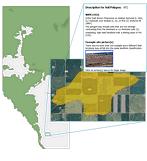
In the top left area of the Alberta Soil Information Viewer welcome page.
2. Left mouse click or tap the  button to get started working in the Alberta Soil Information Viewer environment. button to get started working in the Alberta Soil Information Viewer environment.
3. Left mouse click or tap the maximize viewer button  in the top right corner of banner for the viewer. in the top right corner of banner for the viewer.
Go to the Welcome Page | Go to the top of this page
Find Your Farm
In order to search and zoom to your farm or some other area of interest please read the document on how to Find Your Farm tip sheet available at the Alberta Soil Information Viewer welcome page, or:
1. In the search box located in the top left area of the viewer enter and then tap click one of the following search types:
a. A “legal land description”,

b. A “latitude longitude coordinate pair”,

c. An AGRASID “Polygon number”,

d. A “place name” in Alberta

or alternatively;
e. Open the bookmark window  and select a predefined municipal district, county, large city, or a custom created bookmark for a previous viewer session. and select a predefined municipal district, county, large city, or a custom created bookmark for a previous viewer session.
f. Press or tap the “Go” button 
For the purposes of this exercise lets search and zoom to legal land description on the north east quarter of 23, township 026, range 29 west of the 4th meridian: search and zoom for “ne-23-026-29-4”.
Go to the Welcome Page | Go to the top of this page
General Information
Once a “searched and zoomed’ event has been initiated for a farm location or other area of interest:
1. Change the “functioning mode” to Soil Polygon Labeling and
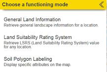
2. Checkmark “Polygon ID”
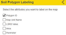
3. Left mouse click or tap the “less than” icon  at the bottom of the Soil Polygon Labeling window. at the bottom of the Soil Polygon Labeling window.
4. Left mouse click or tap the “show the select toolbar ” icon in the vertical tool bar located in the top right section of the mapping area of the viewer  . .
5. Left mouse click or tap the “select drawing rectangle”  . .
6. Draw a box in the mapping area inside of section 23 township 026 range 29 west of the 4th meridian.
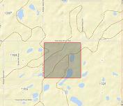
7. Choose the “General Land Information” functioning mode.
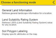
8. The “functioning mode” for the side window is changed to “General Information”
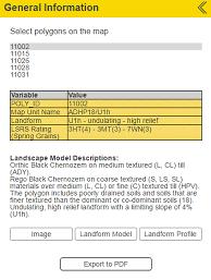
a. Note that “Poly_ID” also known as “Polygon number” 11002 is highlighted grey in both the list, and the mapping area of the viewer.
b.There is a summary table of some general soil attributes of soil polygon id (POLY_ID): 11002.
c.Note the information made visible or the activity that is initiated when the following buttons are left mouse clicked or tapped:
i.“Image” 
ii. “Landform Model” 
iii. “Landform Profile” 
iv. “Export to PDF” 
d. Left mouse click or tap the next “Polygon ID”: 11015 in the list or selected soil polygons and note any changes the information and function in the General Information Window and mapping area of the viewer.
9. Left mouse click or tap the “less than” icon  at the bottom of the “General Information” window. at the bottom of the “General Information” window.
Go to the Welcome Page | Go to the top of this page
Land Suitability
For a relative sense of the soil suitability for spring seeded small grains at or near your farm or area of interest please refer to the Know Your Land Suitability “How to” tip sheet on the Alberta Soil Information Viewer Welcome page, or for a quick look:
1. Change the functioning mode of the left hand side window to “Soil Polygon Labeling” and check mark both the “Polygon_ID” and the “LSRS Value” label.
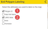
2. Left mouse click or tap the “less than” icon  at the bottom of the “Soil Polygon Labeling” window. at the bottom of the “Soil Polygon Labeling” window.
3. Change the functioning mode of the left hand side window to “Land Suitability Rating System” (LSRS).
4. Enter spatial coordinate in the “Search” box for the farm or area of interest.
5. Press enter or left mouse click or tap the magnifying glass icon 
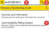
6. Select one or more AGRASID soil polygons using one of the selection icons introduced earlier in points 4 and 5 in the general information section of this document.
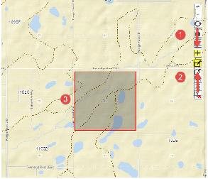
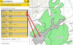
7. Inspect the LSRS Spring Grains values for each tabular record associated with each AGRASID soil polygon number (POLY_ID) selected in the mapping area of the viewer.
8. Note the one to one correspondence between the bold outline of the currently sub selected LSRS record and the grey highlighted polygon in the mapped area of the viewer.
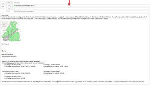
9. Generate an Email of all the selected polygons and there LSRS values. Add a screen capture of the selected soil polygons.
10. Send the email.

11. Left mouse click or tap the “less than” icon  at the bottom of the “Land Suitability Rating System” window. at the bottom of the “Land Suitability Rating System” window.
Go to the Welcome Page | Go to the top of this page
Specific Information
Many clients have asked for more specific soil information for AGRASID soil polygons of interest to them. The “Specific (AGRASID soil) Information” begins to address this client requirement.
1. Search and Zoom to AGRASID Polygon number (Poly_ID): 11002,
2. Change the “functioning mode” to Soil Polygon Labeling and
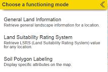
3. Checkmark “Polygon ID” and “Map Unit Name” label options.
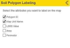
4. Left mouse click or tap the “less than” icon  at the bottom of the Soil Polygon Labeling window. at the bottom of the Soil Polygon Labeling window.
5. Change the functioning mode of the left side window to “Specific Information”
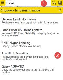
6. Toggle the “Right Pointing Chevron”  or “Down Pointing Chevron” or “Down Pointing Chevron”  icon so that the various specific soil information tables are hidden icon so that the various specific soil information tables are hidden or opened or opened  : :
a. Soil Polygon table

b. Component table(s)

c. Soil table(s)
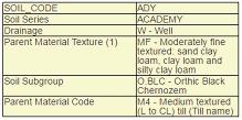
d. Layer table(s)
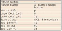
For further information on the definition of the content in each specific information tables listed above, please refer to the Location 10: Specific Soil Information Discovery section of the Run the Viewer “How to” document.
7. Things to note:
a. An AGRASID soil Polygon must be:
i. Selected, or alternatively, highlighted in order for specific information to be accessed about a soil polygon.
ii. Selected soil polygons are shaded a transparent green while an individual soil polygon may be highlighted gray in the mapping area of the viewer.
iii. The General Information”, “Specific Information”, or “Query AGRASID” functioning modes of the left hand side window only display data when:
b. Searching by Polygon number (Poly_ID) not only “searches and zooms” to the AGRASID polygon of interest, it also automatically selects / highlights the polygon in soils data layer of the viewer. Because of this, both the general and the specific information about this AGRASID polygon are instantly available to the left side window’s “General Information”, “Specific Information”, or “Query AGRASID” functioning modes.
c. If searching is achieved by a method other than then by searching for a specific POLY_ID number, it is necessary to select soil polygons using one of the following icons in the vertical tool bar in the top right location of the mapping area of the viewer:
i.  Show the “select (soil polygon)” tool bar. Show the “select (soil polygon)” tool bar.
ii.  Close the “select (soil polygon)” tool bar. Close the “select (soil polygon)” tool bar.
iii.  “Select (soil polygons)” by dragging a rectangle using the mouse or gestures. Soil polygons touching the drawn selection rectagle become selected in the map area of the viewer. “Select (soil polygons)” by dragging a rectangle using the mouse or gestures. Soil polygons touching the drawn selection rectagle become selected in the map area of the viewer.
iv.  “Select (soil polygons)” by drawing a multi-segmented polygon using the mouse or gestures. Soil polygons touching all or a portion of the drawn selection polygon become selected in the map area of the viewer. “Select (soil polygons)” by drawing a multi-segmented polygon using the mouse or gestures. Soil polygons touching all or a portion of the drawn selection polygon become selected in the map area of the viewer.
v.  “Select (soil polygons)” by a buffer (see markup tools Location15 for further information on buffer creation). By left mouse clicking or tapping the “select by buffer tool”, and then left mouse clicking or tapping the preferred buffer polygon all soil polygons that touch the buffer polygon will be selected. “Select (soil polygons)” by a buffer (see markup tools Location15 for further information on buffer creation). By left mouse clicking or tapping the “select by buffer tool”, and then left mouse clicking or tapping the preferred buffer polygon all soil polygons that touch the buffer polygon will be selected.
vi.  “Select (soil polygons)” by a markup polygon (see markup tools Location15 for further information on point line and polygon markup creation). By left mouse clicking or tapping the “select by markup tool”, and then left mouse clicking or tapping the preferred markup point line or polygon all soil polygons that touch the buffer polygon will be selected. “Select (soil polygons)” by a markup polygon (see markup tools Location15 for further information on point line and polygon markup creation). By left mouse clicking or tapping the “select by markup tool”, and then left mouse clicking or tapping the preferred markup point line or polygon all soil polygons that touch the buffer polygon will be selected.
vii.  “Clear selected (soil polygons)” by left mouse clicking or tapping on this icon. “Clear selected (soil polygons)” by left mouse clicking or tapping on this icon.
viii.  On a final note, the ability to select individual soil polygons may be done with or without initiating the “the select (soil polygon) tool bar” an individual soil polygon may be selected by moving the cursor to the preferred location in the map area of the viewer and then left mouse clicking , or tapping. On a final note, the ability to select individual soil polygons may be done with or without initiating the “the select (soil polygon) tool bar” an individual soil polygon may be selected by moving the cursor to the preferred location in the map area of the viewer and then left mouse clicking , or tapping.
Go to the Welcome Page | Go to the top of this page
For further details of other tasks such as how to: Run the Viewer return to the Alberta Soil Information Viewer Welcome Page and browse the “Read How to:” or “Watch How to: ” sections of the welcome page.

Contact the Ag-Info Centre, toll-free in Alberta at 310-FARM (3276), for further soil viewer and agricultural information. |